


MKO is supporting the Geological Survey Ireland (GSI) with the implementation of the Groundwater Climate (GWClimate) project. This four-year project investigates how climate change is impacting groundwater levels across Ireland. Working in collaboration with Met Éireann, National Parks and Wildlife Service, CDM Smith, and South East Technological University, MKO is leading a multi-disciplinary team of scientists that engages with data acquisition and processing, hydrological modelling, hydrogeological interpretation, and climate change impact assessment. In this endeavour, MKO liaises with and reports to the Groundwater and Geothermal Unit at GSI.
Climate change is already changing Ireland’s natural environment, and more extreme flood and drought events are predicted to both occur more frequently and intensify in the coming decades. For these reasons, the ability to forecast and quantify such influences on groundwater levels is front and centre in GSI’s stated goals. The principal beneficiaries of outcomes and outputs will be stakeholders responsible for, and otherwise engaged with, drinking water supply, infrastructure planning and management, and environmental protection.
GWClimate delivers data, modelling tools, and learning that will help to inform national adaptation strategies for groundwater flood and drought risk management.
Now in its third year, the project has produced a series of tangible outputs, as follows:
- An expanded national groundwater level monitoring network, based on new field installations and instrumentation.
- A data management system to support GSI’s website, gwlevel.ie, which is updated regularly with groundwater level data from the expanded national monitoring network.
- A national map of groundwater flow systems that are more and less susceptible to climate change dynamics.
- Hydrological models of 154 monitoring sites across the country, which are used to support hydrological analysis of historical conditions for groundwater levels as well as short and long term forecast of groundwater levels.
- A validation of Met Éireann’s TRANSLATE dataset of national climate projections, in the context of hydrological modelling.
- A groundwater level forecasting system, for use by GSI, which in the future will be made available to interested stakeholders.
- Seasonal groundwater flood extent maps, based on the processing of satellite data.
Associated with each of these outputs are additional outcomes and products, such as characterisation of flood and drought events, analyses of extremes, trends, and climate change points, and workflows, routines and codes that underpin the range of outputs from the project. The latter will serve as the basis for GSI’s subsequent initiatives, following the conclusion of the GWClimate in mid-2027.
The modelling approach that has been adopted for GWClimate provides the basis for assessing groundwater flow system behaviour at both short (flood forecasting) and long (climate change impact) timescales. The combined outputs will thus contribute to enhancing the planning and management of groundwater resources, including the reliability of groundwater flood and drought responsiveness across the country.
Building upon the GSI’s previous Groundwater Flood project, GWClimate makes use of global climate models and hydrological modelling tools to forecast seasonal groundwater flood and drought across Ireland.
Groundwater level monitoring and maintenance
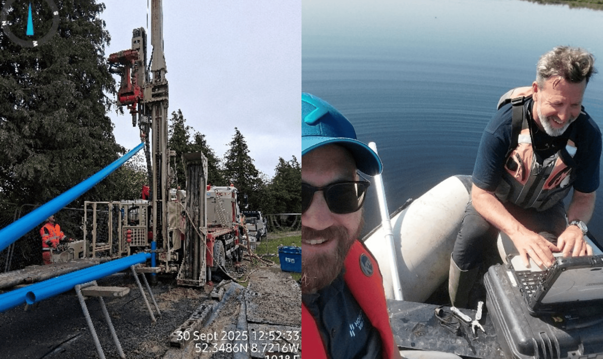
MKO is supervising the drilling and installation of 20 monitoring wells to expand GSI’s existing long-term groundwater level monitoring network in different types of groundwater flow systems across Ireland. MKO is also maintaining existing and updated monitoring installations at 154 sites by conducting routine field visits to help GSI check, calibrate, download, measure, and deploy/re-deploy related equipment, including telemetry installations. The use of representative, high quality data is a project need and a basic requirement for climate change assessment.
Hydrological Modelling
MKO is leading the hydrological modelling with time-series data from 154 groundwater level monitoring sites across Ireland. The modelling considers existing long-term records, derived from both GSI and the Environmental Protection Agency. The modelling involves calibration and validation of the measured data, as a step towards predicting how groundwater levels will respond under future climate conditions, based on weather forecasts from Met Éireann and from the European Centre for Medium-Range Weather Forecasts in the short- and medium- terms, and from TRANSLATE climate projections in the long-term. The modelling tools used are Pastas, Aquimod2, and UisceMod, the latter being a tool developed during a previous phase of GWClimate to model floods in turloughs.
GWClimate is producing data, analytical tools and related codes which will allow GSI and other researchers to advance the characterisation and understanding of hydrological systems as well as the assessment of climate change impacts on groundwater in Ireland.
Groundwater level forecasting
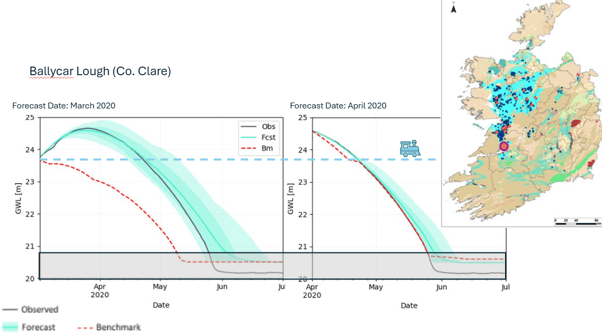
MKO has developed a groundwater level forecasting system to predict (forecast) the probability and duration of drought and flood events at sites across Ireland. The forecasting system has been acid-tested through meetings and a workshop with stakeholders who have shown an interest in the practical use of outputs, including local authorities, the Office of Public Works, Uisce Éireann and Iarnród Éireann.
Seasonal flood mapping
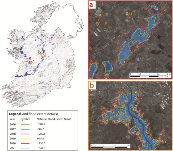
MKO is producing satellite-derived Seasonal Flood Maps and updating the GSI Maximum Historic Groundwater Flood Map. The maps are produced through a semi-automated framework for mapping non-urban flood extents using Sentinel-1 radar imagery. The maps have so far demonstrated value in supporting infrastructure planning. Complementing the flood mapping programme, MKO is further implementing a GSI-developed system that leverages satellite imagery to monitor turloughs, expanding the existing monitoring network to over 100 sites across Ireland.
Drought vulnerability map
MKO is mapping the vulnerability of Ireland’s groundwater systems to climatic drought. Vulnerability is defined as the predisposition of groundwater flow systems to be adversely affected by drought conditions, capturing both how readily a system enters a drought state and how quickly it can recover. The resulting map allows water suppliers and management agencies to identify which groundwater systems are most at risk and prioritise adaptation strategies.
Outreach
MKO is working with our project partners to present findings at national and international conferences and to publish papers in professional journals. Presentations have been delivered at the Irish National Hydrology Conference and the International Association of Hydrogeologists Irish Group annual conference, with two further papers accepted for the 53rd World Groundwater Congress in September. MKO has also contributed to the National Framework for Climate Services newsletter, and to the hydrological updates and flood outlook presented by GSI at Lough Funshinagh. The outreach activity has so far also extended to workshops and knowledge-sharing sessions with interested parties, including Uisce Éireann.